
It’s fair to say that all of my life inspiration comes from songs from the 70s. Most of my life is actually modelled on the lyrics to the Billy Joel classic hit Movin’ Out (Anthonys Song) <link: here>. Then there’s the timeless wisdom about dealing with adversity captured in Devo’s Whip It <link: here>. In the case of our Xmas road trip adventure planning, we took inspiration from the bastion of team-based Manliness that is the Village People, in particular, their song Go West <link: here>
Anyone that’s been on a Xmas road trip on the east coast knows that it’s anything but peaceful. This time of year every campsite is taken, the coast road is full of caravans and camper trailers, you’re camping tent wall to tent wall with a million people.
Go West, Life is Peaceful there.
Go West, lots of open air.
So go west we did. We planned an inland Xmas adventure of camping and mountain biking through inland northern NSW.
We started with XMAS at Katie’s parents’ house in Inverell. When we weren’t eating and drinking far too much at the inlaws I was riding at the Inverell mountain bike park, which I’d driven past plenty of times but this was my first ride. I was really impressed. The small country town mountain bike club has built 3 trails all in a circuit, a 1km easy and a 3 and 5km Intermediate loops.

Trailforks Trail map
The 5km loop covered heaps of different riding. In some spots is was loamy, in others loose. Then it had technical rocky sections with massive boulders and one part you seemed to be riding on the surface of the moon. The downhills were great fun and the uphills could get pretty technical . By the end of four laps I had worked out how to carry my speed and pick my lines enough to make it up all the uphills.

Entry Sign

Well placed berms and features were found throughout.

pretty shitty photos, after a phone mishap I was transported back in time to a Samsung S4 with a broken camera lens…
After Inverell we moved on to a free camping area at The Pines mountain bike park in Armidale.

The camp site here is a large parking area at the edge of the pine forest. There’s a short walk to some drop dunnies in the bike park. It’s off the highway and nice and quiet.

The riding consists of a lot of mellow green trails through the pine forest. They’re all reasonably flat and relaxing. There are a few more advanced trails with some small jumps and obstacles. Also, there’s a few sneaky cows on the track that you need to keep an eye out for, and it looked like some kind of drifter was living in a hut in the forest (an actual drifter, not like the wannabe drifters sleeping in their cars at the edge of the forest…)

After enjoying the relaxing Armidale trails we moved on to follow up a hot tip given to us by a family friend at Inverell. They mentioned the old Glen Innes to Grafton Road which winds along the Mann and Boyd River with plenty of nice camp spots and a tunnel that had been dug by hand by convicts. As we were on the Armidale end we decided to drive along the road from south to north and we headed to Nymboida.
On the way to Nymboida we stopped for the night at the Clouds Creek free camp site. It’s next to the Armidale road, and if you’re lucky you can camp right next to the creek like we did.


This was a great find, if we weren’t on the way somewhere else we would have stayed there for a few days. The one funny thing about this camp site was that there were wild chooks!! Unfortunately, there was an overly excited rooster that would start it’s cock-a-doodle-dooing really early in the morning. (seriously, not a sexual innuendo.)
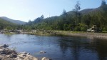
From Cloud Creek campsite we headed on to Nymboida and the Old Glen Innes road. The road winds along the Boyd river and there are a lot of campsites to choose from. It was reasonably quiet considering it was over the new year period and we chose a camp site right next to the river away from the few other campers.

There was a track across the river that I took my bike across to and went for a ride. It led to a lonely scenic lake and stream up in the hills.


This place was paradise. We’ll definitely be back.

Creepy Dalmorton a few k’s upstream from where we camped. The town looked to only have one resident these days. There’s also another campground here by the river.

Apparently hand-made convict tunnel.
After Boyd River we headed to Cangai to camp next to the Mann River. There were a lot more campers here and for some reason I got the impression that the river gets pretty high at times.


When compared to the Boyd river camp Cangai felt a little crowded. After a nice night we decided to head back to Brisbane after a stop off at the Grafton Mountain bike trails, Bom Bom state forest.

After the awesome, well thought out tracks at Inverell, Bom Bom state forest felt pretty lame. It was just some really mellow single track and the features and flow of the track weren’t really all that well thought out. Seemed like it might have been made by road bike riders, or people without much mountain bike experience. This really highlighted how good the Inverell trails were.
We did a lap and then made the drive back to Brisbane.
I really enjoyed getting away from the normal coast based camping trips that we usually do. In general I never really think to head inland, but there are a lot of really great camp spots, often with few or no people and they’re often free. In fact, we didn’t pay any camp fees for the whole trip. It was really nice to be able to swim in fresh water at a lot of the camps. I really enjoyed taking bikes too.
We planned the trip using an app called Wiki Camps (https://www.wikicamps.com.au/) which I highly recommend.
We planned the mountain bike parts of the trip with an app called Trail Forks (https://www.trailforks.com/). About 15 years ago (jesus I’m old) I went on a bike based road trip up the east coast and we needed to use internet forums (they might have been called bulletin boards back then…) or stop at bike shops and chat to people to work out where the trails were to ride. Now with the Trailforks app it makes it really easy to find somewhere to do some skids and hucks wherever you happen to be. It’s awesome.

January 7, 2019 at 5:44 pm
Great maps and information sounds like a plan for future rides. Fantastic information.
LikeLike